Grand Canyon Traverse
Angels Landing and Grand Canyon Rim-to-Rim Trip Report
October 4-8, 2014
Angels Landing and Grand Canyon Traverse Itinerary
Day #1: fly to Las Vegas; get rental car; drive to Zion National Park; overnight at hotel.
Day #2: do Angels Landing hike; drive to Grand Canyon North Rim; overnight at hotel.
Day #3: do Rim-to-Rim hike; overnight at hotel on South Rim.
Day #4: take shuttle bus to North Rim; drive to Las Vegas; overnight at hotel.
Day #5: return rental car; fly home from Las Vegas.

Motivation
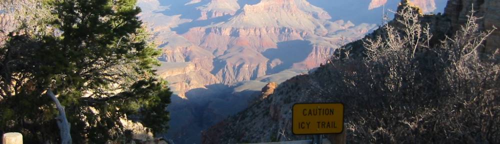
I have done the classic Rim-River-Rim hike from the South Rim of the Grand Canyon five times but never ventured into the inner canyon beyond Bright Angel Campground. The North Rim of the Canyon was a complete mystery to me. For several years I have been meaning to fix that situation by doing a North Rim to South Rim traverse.
…The North Rim of the Grand Canyon was a complete mystery to me.
For me, getting to the Grand Canyon involves flying to Las Vegas first. Serendipitously, Zion National Park is about halfway between Las Vegas and the North Rim. That makes a diversion to Zion a compellingly attractive option. Zion is where the legendary Angels Landing hike can be done. Angels Landing has been on my must-do list for almost as long as the Rim-to-Rim traverse.
Grand Canyon Logistics
The only part of the trip that requires lead time and a little luck is getting rooms at the Grand Canyon Lodge- North Rim and one of the several hotels on the South Rim.
You absolutely want to stay at the Lodge on the North Rim because the only alternative is a 45-mile drive away. The Lodge is a fairly small hotel consisting of a group of freestanding log cabins plus a block of traditional motel rooms. As the only game in town it fills up fast. In addition, the season is limited: it is only open from May 15 through October 15. I was lucky enough to book a “frontier cabin” with just ten days advance notice.
The lodging situation on the South Rim is better with several on-site hotels to choose from. However, given the huge popularity of the South Rim getting a room can still be very dicey. Ideally, you want the Bright Angel Lodge because it is only steps away from the Bright Angel Trail and ending point of the Rim-to-Rim hike. I had to settle for a room at the Yavapai Lodge about a mile away.
Getting back to the North Rim after completing the hike and overnighting on the South Rim is very easy. Trans-Canyon Shuttle runs a regularly scheduled van service that departs the Bright Angel Lodge at 8am and arrives at the North Rim four-and-a-half hours later. Reservations are necessary.
Other Logistics
The 167-mile drive from Las Vegas to Springdale, Utah at the doorstep of Zion National Park takes about two-and-a-half hours. I was unable to get a room at the Zion Lodge inside the park. However, there are lots of hotels in Springdale that are convenient and attractive. It was just a five-minute drive from my hotel to the park gate and Visitors Center parking lot.
The drive from Zion to the North Rim is 111-miles long. It takes about three hours to complete the trip.
The drive back to Las Vegas from the North Rim is 268-miles long and takes about four-and-a-half hours. I stayed in Las Vegas overnight and flew home the following morning.
Angels Landing Hike: Overview
Length: 5.4 miles roundtrip
Getting to the Trailhead: park at Visitors Center lot and take free bus to the Grotto stop; cars are not permitted to drive to the trailhead.
Vertical Gain: 1,488 feet
Elevation at Summit: 5,788 feet
Time required: 2 hours 35 minutes
Grotto Bus Stop to Scout Lookout—39 minutes
Scout Lookout to Summit—34 minutes
Photos/rest—15 minutes
Summit to Scout Lookout—31 minutes
Scout Lookout to Grotto Bus Stop—36 minutes
Trip Report
I arrived at my hotel in Springdale, Utah at about 5 pm on Saturday, October 4, 2014 and took a quick trip to the park to look around. The Ranger at the gate sold me a $10 “interagency senior pass” that surely is the best reward I have ever found for making it past age 62 (I am actually 66). The pass is good for a lifetime and allows unlimited free entry into any National Park in the country.
I parked at the Visitors Center just inside the gate and learned that the first bus to the various trailheads and attractions would leave at 7 am the next morning. Although I had entertained hopes of being able to drive to the trailhead, I learned that cars are not allowed on Zion Canyon Scenic Drive.
…Zion is a stunningly beautiful place.
Zion is a stunningly beautiful place. It showed particularly well in the late afternoon sun and was a wonderful mix of starkly rugged sandstone cliffs and green bottomlands where the Virgin River wove its way through the canyons. It struck me that Zion is like the Grand Canyon in reverse. Here you look up to appreciate the magnificence, there you look down.
I left my hotel at 6:40 am Sunday morning and arrived at the park in plenty of time to catch the 7 am shuttle bus. Dawn was still a few minutes away at that point but by the time I arrived at the Grotto bus stop twenty minutes later light had started to flood the upper reaches of the mountains. It was a cool 55°F and the day promised to be beautiful with cloudless deep blue skies. About fifteen people got off the bus with me, all aiming for Angels Landing.

It was immediately apparent that route finding would be no problem on the lower portion of the hike. Signs helpfully pointed the way to the West Rim Trail on the other side of a footbridge over the Virgin River. One sign in particular garnered a lot of attention. It pointed out that “Since 2004 six people have died falling from the cliffs on this route.” Prior to coming to Zion I had read a lot about the infamously exposed last half-mile of the route and seen several hair-raising YouTube videos that left nothing to the imagination about the serious nature of the exposure. Nonetheless, I was there and had to see for myself.

The first part of the hike to Angels Landing is extraordinarily pleasant. The West Rim Trail is scenic, perfectly maintained and completely cement-paved. With no rubble, water-bars or step-ups to surmount you gain altitude very quickly and easily. After about a mile-and-a-half on the trail you are about 600 feet above the valley floor and enter Refrigerator Canyon. Refrigerator Canyon is a narrow slot canyon with the stupendous Angels Landing rock peninsula forming its eastern wall and Cathedral Mountain towering on the other side. After entering these cool and shady precincts the trail proceeds due north for a half-mile gently rising another 200 vertical feet along the way. Eventually you reach a short stretch of metal pipe fence guarding the outside edge of the trail and turn right to begin the ascent of the famous Walter’s Wiggles.
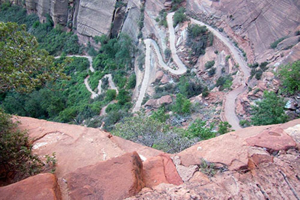
…Walter’s Wiggles comprise possibly the most iconic section of trail anywhere in the National Park system and are a stunning engineering tour de force.
Walter’s Wiggles (named after the 1920s park superintendent who designed and built them) is a section of twenty-one tight switchbacks that allows hikers easy access to the lower portion of the Angels Landing rock spine. The Wiggles comprise possibly the most iconic section of trail anywhere in the National Park system and are a stunning engineering tour de force. They were carved out of the mountain wall using nothing more than hand tools and human sweat. As you ascend them you cannot fail to appreciate their brilliant design. Each zig-and-zag gains you about twelve vertical feet. When you top out at Scout Lookout and peer back down you are doubly astonished. It seems impossible that something that appears so amazingly steep was so trivially easy to come up. When you reach Scout Lookout you are 2.2 miles into the hike and at 5,350’. Your starting point at the Grotto is 1,053 vertical feet below you.

Scout Lookout is a pleasant place. The views are breathtaking and the small plateau is comfortingly broad and flat. I had hiked a bit faster than the other folks on the first bus and had the place all to myself for five minutes or so.
It was well that I did because a quick survey of where the trail went next left me filled with dread.
Seeing the videos and looking at other peoples’ pictures of the route from Scout Lookout to the summit do not prepare you for actually experiencing the place in person. The reality of the thing was absolutely terrifying. Bare slabs of tilted sandstone with rounded ridges marched off into the distance. The summit was still a half-mile distant and 435 vertical feet above where I stood. I had one of those “you can’t get there from here” moments where the task in front of me seemed paralyzingly frightening. I bitterly regretted my fast ascent to the Lookout and wished that others were there…if for no other reason than to witness my inevitable fall and report it to the authorities.

In any event, I collected myself and after caching my backpack and trekking poles began the scramble to the summit. I was infinitely cheered when I looked back a few minutes later and saw that a fit-looking young couple had reached Scout Lookout and were beginning to follow in my tracks.
…The chains were my truest and best friend and I clung to them with a grip that Hercules could not have broken.
The National Park Service has equipped the route with metal stanchions and chains and I blessed those chains a thousand times during the ascent. The chains were my truest and best friend and I clung to them with a grip that Hercules could not have broken. The only problem was that the chains appeared only intermittently on the route. There were horrifyingly long gaps where you were completely on your own with vertiginous drops on either side and downward sloping rock slabs that promised an impossible-to-arrest slide culminating in a thousand-foot freefall. Moreover, there was one place where the trail was indistinct and seemed to offer a variety of options. I took one of these up a twenty-foot high rock redoubt to a wind-tortured pinion pine on top. I thought I remembered the place from some of the pictures I had seen. The male half of the young couple followed in my tracks and, clinging for dear life to the pinion pine we decided that we were off route. He astutely identified the real track below and to the right and I followed him down to it.
The narrowest portion of the trail to the summit has to be seen to be believed. You go downhill to a breathtakingly thin fin of rock that is barely wide and level enough to walk on. On either side is a drop of over a thousand feet passing rock faces so steep that there would be no bouncing along the way as you fell to the bottom of the canyon. I am quite sure that my death grip on the chains was such that I bent the stout metal links with my bare hands.

After passing the mountain’s exceedingly narrow waist there was a 400-vertical foot scramble to the summit plateau. I found the route daunting every inch of the way. Nonetheless, I sensed that the worst was over and even found time to admire the thoughtful work that went into the construction of the trail. In numerous places steps had been scooped out of the unforgiving rock in just the right places to allow safe ascent; in other sections natural rock bulwarks were used to impart a sense of security and allow the climber to mentally prepare for the next exposed section. It was absolutely clear that a lot of intelligent and careful work had gone into building the trail from Scout Lookout to the summit. Apart from the chains, the artificial improvements that make the route do-able by ordinary folk were so subtly wrought as to be invisible on first impression.

…About a half-hour after leaving Scout Lookout I arrived at the summit. I was grateful beyond words to be there in one piece.
About a half-hour after leaving Scout Lookout I arrived at the summit. I was grateful beyond words to be there in one piece. The day was perfect and the views from another, better world. However, my sense of danger was still on high alert and I never really relaxed during the quarter-hour I spent at the top. I was horrified when I saw a couple of chipmunks leaping carelessly from one rock to the next. No power on earth could have induced me to run around as they were doing. I fretted about the descent and its real and imagined perils; more than anything else I just wished to be on safe ground again (the promised land of Scout Lookout!).

As it turned out, the descent was not nearly as scary as the trip up. First, a cohort of people was on their way up and this eliminated all route finding questions. Second, on looking at the demographics of the folks on the way to the top I came to the conclusion that old ladies and two-pack-a-day smokers do this route every single day. The sheer ordinariness of the crowd was a revelation. Up to that point my internal assessment was that only super-fit mountaineers with ice water running through their veins could tackle the route. The reality was that everyone and his friend were on their way to the summit. While this fact took a little luster off the pride I felt in undertaking the route myself, it was also a source of real encouragement. In any event, 31 minutes after leaving the summit I was again back on the comfortably broad and thoroughly safe Scout Lookout plateau. I was completely elated to be on easy ground and have the difficult part of the hike behind me.
The hike back to the Grotto was quick and easy. I was so happy to have made it to the top that my feet barely touched the ground. From start to finish the Angels Landing hike took me only two hours and thirty-five minutes. It was not a long hike by any means but was an adventure that ranks among the best National Park experiences I have ever had.
…I immediately bought an Angels Landing tee shirt!
Upon returning to the Visitors Center I immediately bought an Angels Landing tee shirt!
Final Thoughts
We live in litigious times. In spite of this, the National Park Service allows visitors completely unrestricted access to Angels Landing. No permits, mental health exams or fitness tests are required. Anyone who wants to try the hike is invited to do so. Apart from a hiker’s common sense and instinct for self-preservation, the only prompting the NPS does to caution aspirants is the sign pointing out that people are sometimes killed while attempting the route. I think the NPS’s laissez faire policy is both admirable and brave.
Honestly though, I do not think it will last. Every time someone does fall there is a clamor for regulation. It is abundantly clear that the climb to the summit is not for everyone. Yet, seemingly, everyone is ready to try it. We may be just one tragedy away from the kind of permitting system that prevails in places like Yosemite and Mt. Whitney. It would be a shame if that happened and the thrill of the ascent was encumbered with well-meaning regulations.
My advice? Do the hike now while you can. Surviving to tell the tale is its own reward.
Onward to the North Rim
I got on the road after summiting Angels Landing at 11:30 am and thoroughly enjoyed the three hour drive to the North Rim. The first twenty miles of the trip was on the Zion-Mount Carmel Highway which switch-backs its way through some of the most spectacular viewing points in the whole National Park. A highlight was the 1.1 mile long tunnel leading to the east entrance of the park. The tunnel was chiseled out of solid rock and has intermittent viewing galleries that allow fantastic glimpses of the mountains and valley below. It pleased me to think about the extravagance of the circa-1930 galleries; their only purpose was to give drivers a splendid view. The galleries have been surprising and delighting motorists ever since the tunnel first opened.
…If there is any hotel on earth with a better view, I do not know of it.
The Grand Canyon Lodge- North Rim is perched at the very edge of the Grand Canyon and is an impressive native stone and timber structure. However, the exterior is nothing compared with the interior. On entering the lobby you are immediately welcomed by twenty foot high floor-to-ceiling windows in the dining room to your right and sun room straight ahead. The windows provide a completely unobstructed view of the Grand Canyon in all of its magnificence. If there is any hotel on earth with a better view, I do not know of it.

After checking in, I was promptly installed in one of the many “frontier cabins” on the property. The small log cabin was rustic, TV-less and, as I found out later when the night got cold, completely unheated.
In the waning hours of the afternoon I drove a couple of miles north of the Lodge to scout out the North Kaibab Trailhead. There was a parking lot at the trailhead and it was filled to capacity with fifty or so cars. Cars also lined the road shoulders in the last quarter mile before and after the trailhead. Evidently the National Park Service is tolerant of hikers who park on the roadside when the official lot is packed. I hoped that I would be able to find a space there the next morning.

Grand Canyon North Rim to South Rim Traverse Overview:
Length: 24.0 miles
Getting to the Trailhead: drive to trailhead lot 2 miles from hotel
Vertical Drop North-Rim-to-River: 5,841 feet
Vertical Gain River-to-South Rim: 4,460 feet
Time Required: 9 hours 31 minutes
One of the oddities of Arizona is that daylight saving time is not observed there. The minus-one-hour time change between Zion and the Grand Canyon meant that sunrise came an hour earlier and I was able to begin my hike that much earlier than the day before.
By leaving the hotel promptly at 6am I arrived at the trailhead in time to get one of the few remaining parking spaces in the lot. It probably helped that it was a Monday and the large weekend crowds were gone.
It felt incredibly relaxing to be doing a hike with absolutely no dangers at all. The morning was crisp and chilly with temperatures in the high 30°F range. I was very happy to be moving and generating some body heat because my night in the “frontier cabin” had been exceedingly cold. Because I was going downhill the 8,243 foot altitude at the trailhead caused no discomfort at all.
…The North Kaibab Trail is a wonderful trail. It was built to the same high standards as the other Grand Canyon “superhighways.”
The North Kaibab Trail is a wonderful trail. It was built to the same high standards as the other Grand Canyon “superhighways,” the South Kaibab Trail and the Bright Angel Trail. One gigantic advantage it enjoys over the other two is that it gets very little mule traffic. Heavy mule traffic on the south side of the canyon, both to carry tourists back and forth and to provision the enormously popular Phantom Ranch, really tears the trails to pieces. On the North Kaibab the tourist mule trains only go down as far as the Supai Tunnel and they are few and far between to begin with.
Trailhead to Ranger House
I made quick progress along the trail and in the first half hour passed a couple dozen early starters. Everyone seemed to be in good spirits and grateful for the perfect, sunshiny day. I envied the folks who had brought their fleece gloves along!

The first major waypoint on the trail, the Supai Tunnel, comes about 1.7 miles into the hike. The tunnel is short and utilitarian. You can clearly see the chisel marks its makers left eight decades ago. However, upon emerging you enter into one of the most beautiful sections of the whole traverse, the fabulously switchbacked passage to Redwall Bridge and Roaring Springs.
The hike from the tunnel to Redwall Bridge is thoroughly enjoyable, all the more so because from your high vantage point at the tunnel’s other side you can see most of the trail as it loops and zig-zags deep down into the canyon below your feet. The trail is well maintained and in the space of a mile drops over eight hundred vertical feet. It is so artfully built that the long drop seems perfectly reasonable.
Redwall Bridge was built in 1966 after a flood destroyed the old bridge. It gets its name from the redwall limestone layer of rock that exists at that point in the geologic cake slice of the canyon. It is an excellent steel bridge that is sturdy and secure and the first of six footbridges that you encounter on the way to Phantom Ranch.

…what makes Roaring Springs really impressive is that it is the source of all of the drinking water used on the North Rim, all of the water on the trail and most of the water on the South Rim.
A mile or so after crossing Redwall Bridge you pass Roaring Springs across the canyon on your left. Roaring Springs is a modest-looking natural feature that many people pay little attention to. It is a hole in the canyon’s steep face out of which a torrent of water rushes forth to form Bright Angel Creek four hundred vertical feet below. Bright Angel Creek is your constant companion on the route all the way to the Colorado River. However, what makes Roaring Springs really impressive is that it is the source of all of the drinking water used on the North Rim, all of the water on the trail and most of the water on the South Rim.

Near Roaring Springs you see a pumping station and helicopter pad. The pumping station sends water from the spring up to the North Rim. Gravity transports the water through the trans-canyon pipeline in the other direction all the way to Indian Garden where other pumps then bring it the rest of the way up to the South Rim. By providing sparkling clean fresh water in abundant quantities Roaring Springs is an indispensable contributor to the Grand Canyon’s success as a tourist destination. It seems incredible that this modest hole in the rock is the lynchpin of the infrastructure that millions enjoy every year.
I took my first rest break at the Ranger Residence 5.3-miles and about two hours into the hike. It was nice to sit on a bench in the shady clearing, have a little food and fill up on water. The day was beautiful and had warmed up to around 55°F so I was able to stash my light fleece jacket in my pack for the duration of the hike.
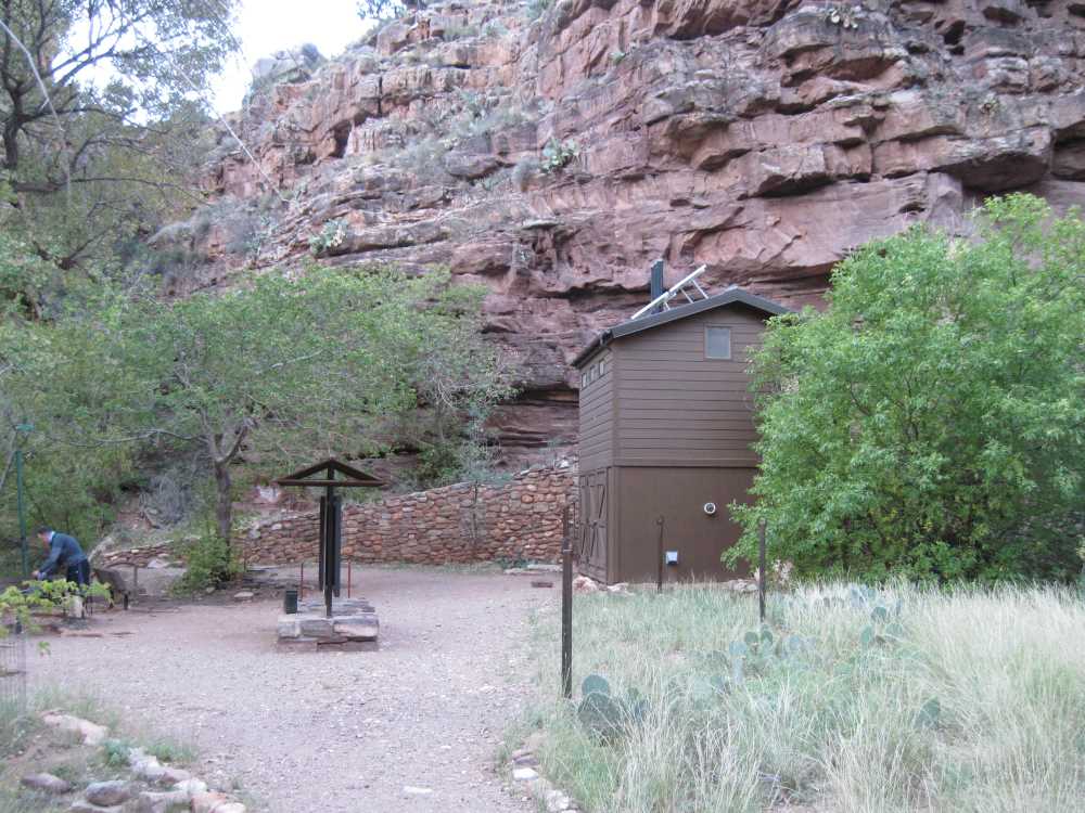
The Ranger Residence, also known as the pumping station caretaker’s house, is where NPS employee Bruce Aiken and his family lived for many years. The enterprising Aiken kids were famous for selling lemonade to hikers. Besides tending the pumps, Aiken found inspiration in the Canyon and produced a large body of art. After thirty-three years there he retired to become artist-in-residence at an Arizona university.
Cottonwood Camp to Colorado River
About a mile and a half and 1,030 vertical feet below the Ranger Residence you hit Cottonwood Camp. Cottonwood is a popular stopping point for campers who are doing multi-day excursions in the Canyon. Tent sites are available along with abundant water and tree-shaded resting places.
The next major waypoint on the trail is the junction for Ribbon Falls. The junction is somewhat confusingly marked with it being clear that Cottonwood Camp is where you just came from and Ribbon Falls is across the footbridge on your right but nothing to positively indicate where the trail to Phantom Ranch is. However, by avoiding the footbridge and keeping to the left it soon becomes apparent that you are on the correct track to Phantom Ranch. A diversion to Ribbon Falls is well worthwhile but I decided to save that for another day. You add about a mile to the traverse by stopping off at Ribbon Falls.
…It was very impressive to see the result of water erupting from a break 2,500 vertical feet below its source at Roaring Springs.
Three miles further into the trek I came across something that really caught my attention: a giant twenty-foot high geyser of water. Apparently, one of the cleanout valves on the trans-canyon pipeline had failed shortly before I got there. It was very impressive to see the result of water erupting from a break 2,500 vertical feet below its source at Roaring Springs. Not long after passing the geyser I saw a NPS helicopter heading in that direction. No doubt repairs were promptly made.

Eventually, the broad central section of Bright Angel Canyon narrows and you enter the “Box.” The Box is a wonderfully scenic slot canyon that opens up just before you reach Phantom Ranch. It is a great place to hike through and where the final five bridges along the North Kaibab Trail appear within a space of less than four miles. The mystery of the Grand Canyon really comes alive in the Box. Bright Angel Creek is always close by and you get a sense of how it relentlessly carved its way through the rock eons ago. A huge amount of work went into making the trail seem a natural part of the passageway and by the time you are through it you cannot help but be grateful for the builders’ brilliant work.
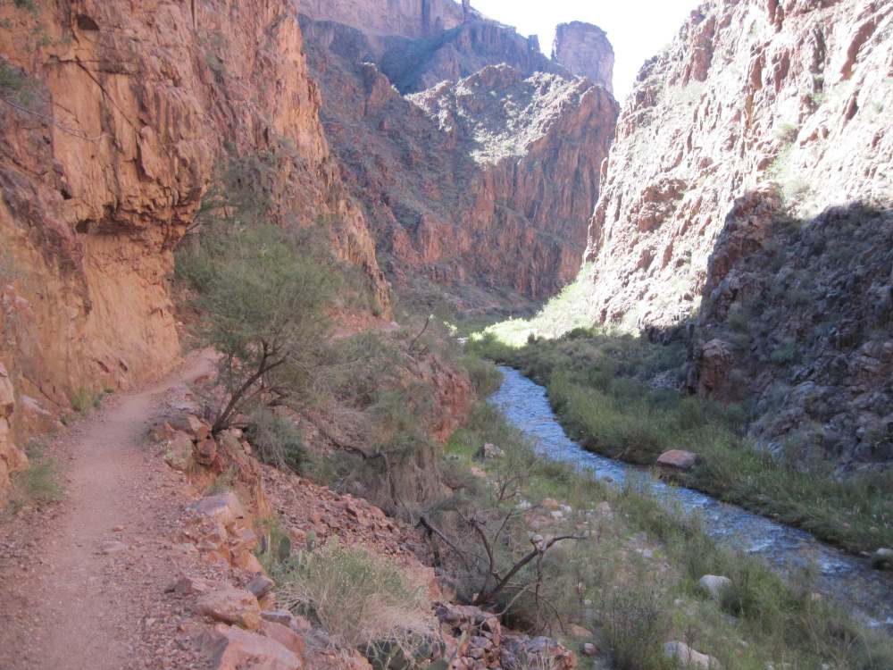
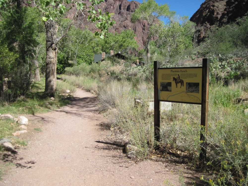
Phantom Ranch is the undisputed Number One tourist destination in the lower part of the Grand Canyon and I was thrilled to see it for the first time. The cabins and other facilities are rustic and welcoming. Someday I would like to stay for a couple of nights and take it all in. However, on this day I had the Colorado River and Bright Angel Campground on my mind. Earlier in the day I had made up my mind that I would not stop until I got to my traditional resting place at the Campground within sight of the Silver Bridge. After close to three hours of continuous travelling that place looked like heaven on earth. Five hours into the hike and with 14.7 miles under my feet I finally arrived back on familiar ground. I plopped down on a bench and felt like I was home!
It was nice to laze around in the shade, nibble on some snacks and enjoy the buzz of activity near the Campground. It occurred to me that I had not passed any hikers traveling in my direction since Redwall Bridge and that I had met fewer than a dozen going the other way. Crowding is not a problem on the North Kaibab Trail.
Bright Angel Trail to South Rim
After a pleasant few minutes of rest I began the uphill push to the South Rim: next stop Indian Garden, 4.7 miles away. Here is where I made a dumb mistake. Instead of walking fifty feet to refill my water bottle, I decided that I would be fine with just the few gulps that remained in it. I quickly hiked across the Silver Bridge and set out on the River Trail to River Resthouse and the start of the Bright Angel Trail. Within fifteen minutes the fact that it was now blazingly hot outside penetrated my consciousness. The near freezing temperatures of the early morning had given way to 90°F at high noon. Although I made the long pull to Indian Garden without incident, I certainly had an unnecessarily parched last mile. Familiarity made me lazy.
…The water, like me, had faithfully made its journey to Indian Garden all on its own power!
There is nothing quite as pleasurable as letting cold water sluice down your throat on a hot and thirsty day. Thus, my forced abstinence was rewarded at the Indian Garden water spigot and it did not hurt at all to remember that I had seen its source just a few hours before at Roaring Springs. The water, like me, had faithfully made its journey to Indian Garden all on its own power!

Indian Garden has lots of benefits for travelers. There are lovely campsites protected by large ramadas, comfortable benches among the cottonwoods, abundant water and clean restrooms. It is a fine place to sit and relax. For many hikers with multi-day itineraries and commensurately large backpacks an overnight stop at Indian Garden makes what otherwise would be a painful death march to the rim a reasonable two-day experience.
I always dread the leg from Indian Garden to 3 Mile Resthouse because it is steep, hot and usually torn to shreds by mule traffic. However, luck was with me and the trail was in fine shape. I motored up to 3 Mile Resthouse in a commendable forty minutes and felt very comfortable in continuing on to 1.5 Mile Resthouse and my last programmed stop of the day.
Traffic on the Bright Angel Trail from 3 Mile Resthouse to the rim is typically heavy; not in the sense that there are throngs of people obstructing the path but rather that someone is always in view. After several hours of comparative isolation it was nice to see lots of other hikers and sense that the manifold comforts of the rim were just a little way off. With the end tantalizingly close at hand I abbreviated my stop at 1.5 Mile Resthouse and headed for the top.
…I clicked the “Stop” button on my watch and was delighted to see that my time for the traverse was a better-than-expected nine hours and thirty minutes.
It was great fun to have the final mile and a half and 1,130 vertical feet disappear under my legs and to finally see Kolb Studio and the end of the Bright Angel Trail come into view. I clicked the “Stop” button on my watch and was delighted to see that my time for the traverse was a better-than-expected nine hours and thirty minutes. From the rim I was able to look back across the canyon and see a glint of reflected light from the windows of the Lodge on the North Rim twelve straight-line miles away. It was incredibly satisfying to have the traverse done and look forward to a hot shower and rest at the Yavapai Lodge. I slept very well that night.

Final Thoughts
Doing the North Rim-to-South Rim traverse is a wonderfully rewarding experience. There were numerous times during the hike that I marveled at how beautiful it was and how lucky I was to be there to enjoy it.
…The traverse is a major physical undertaking that deserves a lot of caution and respect.
Nonetheless, it is a major physical undertaking that deserves a lot of caution and respect. As all hikers know, trail hiking is much slower and more difficult than walking or running on paved pathways. It is remarkable that a twenty minute per mile pace, going downhill every inch of the way can seem “fast” when you are on a backcountry trail. The combination of a lot of miles (24 miles), and a lot of time to do each one of them (figure on no better than 20:00/mile downhill and 25:00/mile uphill) translates into a very long day on your feet. There is nobody who will not be plenty tired after eight or ten hours on his feet. Also, there is sometimes a very thin line between being able to gut out the final few uphill miles and having your body just quit on you. I saw this in the homestretch above Indian Garden where several plainly demoralized and exhausted people looked like they were walking to their own hanging.
It pays to be realistic in deciding whether to do the traverse in one big push. If there is any question, breaking the trip into a two-day event is a great option. Either way, you will have one of the best hiking experiences available anywhere on Earth. I am already looking forward to doing it once again.