Kearsarge Pass
Kearsarge Pass Hike
For those seeking both a challenging high altitude day hike and a near perfect dress rehearsal for the hike to Trail Camp on Mt Whitney, the hike from Onion Valley Campground to the top of Kearsarge Pass fits the bill splendidly. I did this hike in October of 2016.
…a near perfect dress rehearsal for Mt Whitney.
Vital Statistics:
Length (round trip): 9 miles
Elevation Gain: 2,642 feet
Elevation at Top: 11,832 feet
Time Needed: 2:30:00 up / 1:30:00 down

Getting There:
The Kearsarge Pass Trailhead is at the main parking lot for the Onion Valley Campground, a facility near Independence, California run by the US Forest Service. Independence is a small town that California Route 395 goes through. Once you reach Independence, be alert for a sign for the Campground and Onion Valley Road. Head west on it and over the course of about 17 miles of driving you will gain a mile in elevation and arrive at the Campground. The trailhead is at 9,190 feet. The summit of Mt Whitney is only 14 straight-line miles away and you can drive to Whitney Portal from there in under an hour.
Why Do This Hike?
Most people do the hike simply because it is a thoroughly agreeable outing in the wilderness. It is not too long, the terrain is varied and the views of its five alpine lakes are terrific. Provided you are not camping overnight, no permits are needed and you can do it whenever time and weather allow. The Onion Valley Campground is officially open from the beginning of June through the end of October but snowfall may make the trailhead inaccessible at any time. The Campground is well equipped with toilets and plenty of piped-in water.

…Those with ambitions to climb Mt Whitney regard the hike as a wonderful way to acclimatize to the demands of altitude.
Those with ambitions to climb Mt Whitney regard the hike as a wonderful way to acclimatize to the demands of altitude. This is particularly so because the hike has much in common with the hike to Trail Camp on Mt Whitney. Trail Camp is where many Whitney climbers take an overnight break before proceeding to the summit the next day. The similarities are striking:
Kearsarge Trail Camp
Distance 4.5 miles 6.0 miles
Elevation Gain 2,642 feet 3,650 feet
Trailhead Elevation 9,190 feet 8,350 feet
Elevation at Top 11,832 feet 12,000 feet
Elevation Gain/Mile 587 feet 608 feet
For anyone coming from low altitude areas (i.e. below 5,000 feet), doing the Kearsarge Pass hike is excellent training for Mt Whitney. As any experienced hiker knows, hiking at the higher elevations is dramatically more difficult than hiking on mountains near the coast. It takes time for the body to adjust to altitude and until it does walking up the smallest incline feels ridiculously hard. Even after a few days of acclimatization you never completely escape the feeling that your efforts are disproportionate to the results.
…One thing is certain: if you do not acclimatize properly you will hate every upward step you take on the Mt Whitney Trail.
Given the fact that permits to climb Mt Whitney are very difficult to come by, you definitely do not want to risk ruining your chances for success by failing to acclimatize properly beforehand. Two or three trips up to the top of Kearsarge Pass in the days before tackling Mt Whitney will provide acclimatization benefits that will set you up beautifully for a strong outing there. If you are able to combine these day hikes with at least two nights at the Onion Valley Campground (reservations required) your prospects for success will be improved immeasurably. With this level of acclimatization you may actually be able to enjoy your trip up Mt Whitney. One thing is certain: if you do not acclimatize properly you will hate every upward step you take on the Mt Whitney Trail.

Fail-Safe Acclimatization Plan:
Here is a plan that will give you the keys to the kingdom from a Mt Whitney acclimatization viewpoint:
Day #1: arrive at Onion Valley Campground; set up camp; do short orientation hike to locate the trailhead and camp facilities; spend night in tent.
Day #2: do a long and deliberately s-l-o-w acclimatization hike to top of Kearsarge Pass (2 ½ to 4 hours up / 1 ½ to 3 hours down: the slower the better!); return to campsite and take the rest of the day off; spend night in tent.
Day #3: do exactly the same as Day #2.
Day #4: break camp at dawn; drive to Whitney Portal; hike to Trail Camp; set up camp; spend night in tent.
Day #5: leave camp at dawn; hike to Mt Whitney summit; return to Trail Camp; spend night in tent.
Day #6: break camp at leisure; hike back down to Whitney Portal trailhead.
…Acclimatization is like an investment: the more resources you commit to it, the bigger the eventual reward.
This is a very conservative acclimatization plan that will all but guarantee success on Mt Whitney. It will not make the trek to the top of the mountain easy by any stretch of the imagination. You will suffer quite a lot both while doing the Kearsarge Pass acclimatization hikes and on Mt Whitney. However, it will allow you to avoid the distress of Acute Mountain Sickness and your climb to the summit will be less of a death march than it otherwise would be. Acclimatization is like an investment: the more resources you commit to it, the bigger the eventual reward.

Kearsarge Pass Route Description:
The trailhead is well marked and a short distance west of the main parking lot. From it the trail ascends at a moderate rate through patches of sagebrush and manzanita. At about .3 miles in there is a sign for a spur trail to Golden Trout Lakes (stay on the main trail) and a half mile beyond that a sign marking entry into the John Muir Wilderness. The trail is very good but rather narrow. If you are using trekking poles, they will frequently snag on the vegetation.

…Gilbert Lake is at 10,400 feet and very pretty to look at.
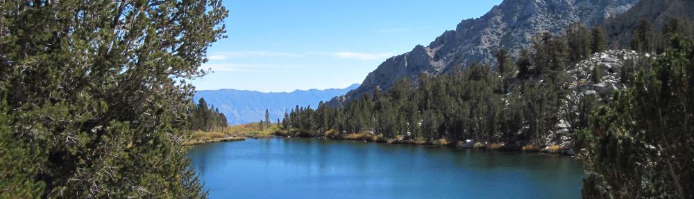
At about 1.5 miles in you will spy Little Pothole Lake well off the trail to the left. Gilbert Lake will appear at 2.1 miles from the trailhead and you will pass right by its shores. It is at 10,400 feet and very pretty to look at. The trail flattens for some distance as you pass Gilbert Lake and at about 2.5 miles in you will glimpse Flower Lake.

…Big Pothole Lake seems to appear out of nowhere and occupies another perfect basin far below your feet.
At the 3.2 mile mark you will be at 11,000 feet and at the end of a hairpin turn you will suddenly see Heart Lake in a basin 200 feet below you. It is a spectacular sight. The trail ascends steadily and by the time you hit the 4 mile mark the vegetation will have largely vanished. As ample consolation for the loss of greenery Big Pothole Lake seems to appear out of nowhere and occupies another perfect basin far below your feet.

The remaining distance to the top of Kearsarge Pass is achieved via one long switchback that encouragingly keeps your goal directly in view. The trail is distinct all the way and its quality is very good.

…The western views down into Kings Canyon are spectacular.
At the top of the pass you are greeted by a sign announcing your elevation (11,760 feet per the sign but more accurately 11,832 feet) and the fact that you have arrived at the boundary of Kings Canyon National Park. The western views down into Kings Canyon are spectacular. Looking back down to the east towards your starting point you can see clear down to the broad valley where Independence is located and the hills beyond. It is in these hills that the famous Kearsarge silver and gold mine was developed in the late 1800s. Tip your hat to the miners who pioneered the route so many years ago!
