Mt Whitney SUCCESS
Background
Oddly enough, I distinctly remember when I first heard about Mt Whitney. I was twelve years old in 1960 and sitting in a 7th grade Social Studies class when the teacher explained that Mt Whitney was the highest mountain in contiguous United States. He showed us a picture of the mountain. I was unimpressed. In a world of snow-capped giants, Mt Whitney’s rocky, saw-toothed outline was nothing to get excited about. I promptly forgot all about Mt Whitney.

It bubbled into my consciousness again in 2016 when I became aware of the astonishing geographic oddity of America’s highest and lowest points being only 85 miles apart. I thought that it would be a wonderful adventure to summit Mt Whitney (14,505 feet) one day and then tag the lowest point in North America, Badwater Basin in Death Valley (282 feet below sea level), the next day.
Chronicled here, my 2016 Mt Whitney to Death Valley Expedition ended in failure. I made the trip to the mountain early in the climbing season and did not bring with me the gear (helmet, crampons and ice axe) needed for the ascent. I had wrongly assumed that the route above Trail Camp (12,000 feet) would be largely snow free. It wasn’t! However, I salvaged something from the trip by marching out into the desert and touching the minus 282 feet continental low point.
Undeterred, I went back to the High Sierras four months later (October 2016) with full mountaineering gear. I was confident that this time I would be able to summit the mountain. Unfortunately, the expedition also ended in failure when a minor emergency at home and a leaky camp stove caused me to cut the trip short without ever having set foot on Mt Whitney. The only thing I gained from the trip was a dry run of an acclimatization plan that I was very confident would work. The write-up of the trip is here. After returning home I decided that 2017 would be my year to do Mt Whitney.
2017 Planning
You cannot simply go to Mt Whitney and climb the thing. The US Forest Service imposes a strict quota on the number of people allowed to be in “the Whitney Zone” on any given day during the May through October climbing season. The Whitney Zone starts at about 10,000 feet in elevation so hikers without permits can only go 2.8 miles up the Mt Whitney Trail to Lone Pine Lake before having to turn around. From Lone Pine Lake, the summit is still roughly 8 miles away. The number of permits is limited to 100 “Day-use” permits for people who want to complete the round trip to the summit in one day and 60 “Overnight” permits for people who camp one or more nights along the way.

With only 160 permits per day to give out and very high demand for every one of them the Forest Service runs a lottery to see who gets them. Details about the lottery are published here.
Most Mt Whitney lottery applications are unsuccessful.
I applied for an Overnight permit within the February 1 through March 15 lottery window and hoped for the best. Like all experienced applicants I chose a “1st choice” date and fourteen secondary choices. On March 24, 2017, I got the bad news: my application for a permit was unsuccessful. I was disappointed but not surprised. Most applications are unsuccessful. The Forest Service annually publishes a review of lottery results that is full of discouraging information. The graphic below says it all:

One big take-away from the Forest Service’s annual lottery review is that it is significantly tougher to get an Overnight permit than a Day-use one. Day-use applications have a 58% success rate while Overnight ones are successful only 24% of the time. The raw “successful” numbers in the graphic simply show the relative proportions of the winners. It ignores the fact that Overnight permit requests outnumber Day-use requests two-to-one.
However, persistence has its rewards. By checking the Recreation.gov website daily and scouring the “Date Range Availability” tab for openings, I was eventually able to get a permit for August 28, 2017. Apparently, someone’s plans changed and that good soul was courteous enough to return his permit to the pool. I wish more people would do this. Typically, lottery winners who decide not to use their permits just forfeit them. Forfeited permits are available to walk-ins at the US Forest Service headquarters in Lone Pine, California but this does not provide much comfort to climbers who live far away.
Acclimatization Plan
Experience has taught me that a lot of misery can be avoided if you acclimatize to altitude before you tackle a climb.
The silver lining to the October 2016 trip that I cut short was that I used it to evolve an excellent acclimatization plan.
The silver lining to the October 2016 trip that I cut short was that I used it to evolve an excellent acclimatization plan. Per the plan, I would camp two nights at the Onion Valley Campground (9,190 feet) and do two acclimatization hikes to the top of Kearsarge Pass (11,832 feet) before driving 40 miles to Whitney Portal and camping there (8,020 feet) for a night before heading up the Mt Whitney Trail.
Immediately upon getting my permit I tried to get a campsite for August 25 and 26 at the Onion Valley Campground and for August 27 at Whitney Portal. Reservations can be made online for Onion Valley here and for Whitney Portal Campground here. Unfortunately, both places were booked solid when I initially tried to get them in May of 2017. My backup plan was to stay for those nights at the Mammoth Mountain Inn in Mammoth Lakes, California. It is located at 8,900 feet and nearby trails allow acclimatization hikes to a bit over 11,000 feet. Its biggest downside is that it is fully 115 miles distant from Mt Whitney and the drive plus the ascent on August 28 would make for a very long day.
As luck would have it I did not have to invoke the backup plan. I regularly checked the Onion Valley and Whitney Portal websites for openings and in early August the dates I wanted became available. Once again, the lesson was clear: persistence has its rewards. I was very happy to be back to Plan “A”.
Acclimatization at Onion Valley
After a three hour flight from Houston to Las Vegas and a five hour, 250 mile drive I arrived at Onion Valley Campground on the afternoon of Friday, August 25. I quickly made camp and was thoroughly pleased with the campsite. It was level, sandy and nicely equipped with a picnic table and bear-proof food locker. A rest room was only 100 feet away. It would have been perfect except for the fact that the piped-in water that is usually available was missing this year. The explanation was that a massive rock-fall had destroyed the catch system high up the hill. I had to drive 17 miles back down to Independence, California to buy bottled water.

Onion Valley is a family-oriented place and that makes for quiet nights and uninterrupted sleep. It is very different in character from some places (e.g. Yosemite) where the party animals revel long into the night.
One night sleeping at altitude helped my acclimatization remarkably.
I woke up early Saturday morning excited to get my first acclimatization hike up the Kearsarge Pass Trail underway. After a leisurely breakfast I enjoyed the 6:30am sunup and started the hike at 7am. It was great to be familiar with the Trail from my 2016 visit and I was very pleased to find the going not-too-tough. One night sleeping at altitude helped remarkably. I went at a deliberately slow pace and covered the 4.5 mile distance to the top of the Pass in 2 hours and 20 minutes. The morning was glorious and it was nice to chat with a couple of other early risers who had come up via the John Muir Trail from the other (West) side of the Kearsarge Pass.

The trip back down the mountain went by in a flash. It took me only 1 hour and 27 minutes to descend. It is amazing how easy it is to go downhill! Here is what Big Pothole Lake looks like when you are starting the hike down from the Pass. It is a beautiful sight.

I arrived back at the trailhead at about 11am. I was happy to have the active portion of my acclimatization regimen for the day finished and looked forward to the equally important rest and relaxation portion. I took the remainder of the day off secure in the knowledge that by just being there at 9,190 feet my blood chemistry was changing in ways that would pay huge dividends a couple of days hence.
After another peaceful night in the tent I started my second and final acclimatization hike on the Kearsarge Pass Trail an hour earlier than the day before. At 6am on Sunday morning the sun was still a half hour from rising but it was plenty light enough to see the trail without a headlamp. It felt wonderful to motor up the now-familiar path and see the landmarks come and go. Without working any harder at all I reached the top of the Pass in 2 hours and 5 minutes, fully fifteen minutes ahead of yesterday’s time. This was a great confidence booster.

I effortlessly descended the trail and was well-pleased with the results of my pre-Whitney acclimatization plan. In all I had spent two nights above nine thousand feet, covered eighteen miles and logged just over a vertical mile of elevation gain while hiking. I was cautiously optimistic that this would be enough.
On to Whitney Portal
I broke camp and left Onion Valley well before noon. I drove direct to the US Forest Service headquarters in Lone Pine, California thirty miles away. There I picked up my permit and proceeded on to Whitney Portal Campground. Along the way I saw a sign proclaiming “No water available at Whitney Portal!” Feeling distinctly unlucky I traced my way back to town to buy water.
The campsites at Whitney Portal Campground are terrific.
The campsites at Whitney Portal Campground are terrific. They are huge, have dedicated parking spots, picnic tables, bear-proof food storage containers, nearby toilets and (usually) running water. This time the water was contaminated with E coli.

After building camp I drove up the hill to the trailhead. The campground is about a mile distant from and 300 vertical feet below the trailhead. My goal was to meet some just-descended climbers and quiz them about conditions on the way to the top.

What I heard was very encouraging: the snow and ice had virtually disappeared from the entire length of the Mt Whitney Trail. The only remnant was a patch about 100 yards long on the final pitch before the Summit Hut comes into view. There was no need to lug crampons or snow spikes up the hill. The guys I talked to had come down from the summit after camping at Trail Camp the night before. They had just bought a six-pack of IPA at the Whitney Portal Store and were clearly enjoying life immensely after a long day’s work on the trail. Lucky fellows!
One Day or Two?
Although my permit was an “Overnight” one that gave me the option of camping at Trail Camp on Monday night before ascending to the summit on Tuesday, I had gone back-and-forth with myself as to whether to try to knock the hike off in one push. Learning that the route was ice-free was all I needed to make the decision. A day hike it would be! While the thought of 22 long miles was daunting, I was thrilled at the prospect of doing them carrying only a 10-pound day pack rather than having to haul a 40-pound backpack all the way up to Trail Camp.
Carrying a big load at altitude is awful work!
The next logistical question to resolve was when to start the hike. The usual advice given to day-hikers is to start anywhere between midnight and 3am. Most groups take ten hours to reach the summit so a start in the wee hours makes sense. Mt Whitney, like most big mountains, is a magnet for afternoon thunderstorms and the safest course of action is to be headed down well before mid-afternoon.
I dislike hiking in the dark so I decided to ignore the advice and hit the trailhead at 5:30am. Based on recent experience I knew that at that hour I would not be stumbling around in total darkness. Also, I felt reasonably good about my prospects of making the top by noontime. Honestly, the biggest concern I had was that of finding a parking spot in the lot near the trailhead in the morning. The place was jam-packed with cars when I visited it earlier in the day.
The Hike
Despite having confidence in the thoroughness of my preparations, my sleep was fitful and I was a bundle of nerves when I woke up at 4:30am to prepare for the climb. After breaking camp and carrying my 50-pound duffel bag 75 feet uphill to the trunk of my rental car I was doubly happy about the choice to do the mountain in one go. Carrying a big load at altitude is awful work! I drove to the parking lot opposite the Whitney Portal Store and was hugely relieved to find a parking place without any trouble. It was Monday morning (August 28, 2017) and I supposed that the big weekend crowds had gone home the previous afternoon.

At 5:38am I clicked the “Start” button on my stopwatch and got underway. I wore a headlamp all the way to Lone Pine Lake but it was useful for only the first twenty minutes or so. It was great to be all alone on the trail and witness the dawn slowly dispelling the early morning gloom.

I made my first rest stop at Lone Pine Lake (2.8 miles from the trailhead). I was surprised to see absolutely nobody on the trail. A bit further on there were a couple of quiet tents at Outpost Camp (3.8 miles from trailhead) but I did not encounter any people until a half mile before Trail Camp fully three hours into the hike. I wondered whether the 160-person per day Whitney Zone lottery quota had been filled.
…nobody needs worry about running out of water while hiking to Trail Camp. The water sources on the route are varied, beautifully clear and plentiful.
I had been to Trail Camp (6 miles from trailhead) once before and it was encouraging that I was feeling much better this time than in 2016. Then I was minimally acclimatized and feeling awful. By comparison, on this day I felt great and looked forward to stopping at the base of the 99 Switchbacks for a bit of food and water before venturing into the terra incognita above. I knew that I was not eating and drinking enough and resolved to make up the deficit before tackling the 99 Switchbacks. Thankfully, nobody needs worry about running out of water while hiking to Trail Camp. The water sources on the route are varied, beautifully clear and plentiful. However, out of caution I chemically treated the water I took from a creek along the way.
Unlike the largely unpopulated precincts below, the 99 Switchbacks had lots of people slowly toiling upward. Surprisingly, no one at all was headed down. I chatted with a dozen or so in three different groups who had adhered to the 3am start dictum and were in varying states of disarray. It was appallingly obvious that they were paying the price for imperfect acclimatization. My heart went out to all of them as I went past.
For me, the highlight of the 99 Switchbacks was reaching the “Cables” section. Broken and tortured as they are, the Cables part of the route is as iconic a section of trail as exists anywhere in the United States. One can only imagine the immense forces that crumpled them into their current shape. Also, I reached them much quicker than anticipated. I thought they were much higher on the face. When I reached them only 30 minutes after ending my rest break it was as if I had received an early birthday present.

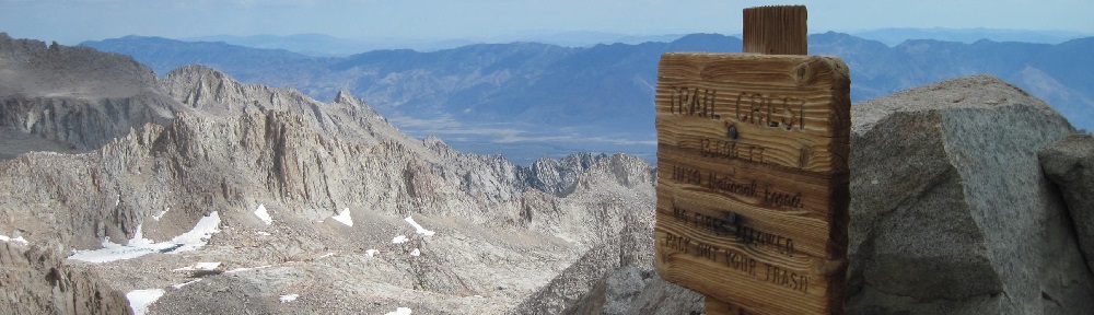
About 45 minutes after traversing the Cables I topped out at Trail Crest (8.2 miles from the trailhead). That too was a wonderful moment. I knew beyond a shadow of doubt that I would make the summit. The views from Trail Crest were spectacular. They made all the work of getting there completely worthwhile. I stopped there for 20 minutes to prepare for the final push to the top.

From Trail Crest, you go downhill roughly 220 vertical feet until you hit the junction between the Mt Whitney Trail and the John Muir Trail. I hated every downhill step because I knew that I would have to recover the lost altitude twice: once on the way to the summit and again on the return to Trail Crest. Somehow it all seemed very unfair! However as ample compensation, two rewards were immediately at hand: more beautiful vistas and a sign proclaiming “Mt Whitney 1.9” miles to go.

Making the final distance to the summit was very hard work. It took me 1 hour and 20 minutes from Trail Crest to do it. The views were majestic but my appreciation of them plummeted in the face of grinding labor on a trail that seemed composed entirely of awkwardly angled slabs, slippery boulders and millions of step-ups. Despite having a couple of distant peeks at the Summit Hut there was little to encourage the spirit in the final 1.9 miles. However, along the way the trail skirts four “windows.” These are the bottoms of the jagged peaks which make up Mt Whitney’s saw-toothed east ridge. I vividly remembered looking up at that ridgeline from the road in Lone Pine a couple of days before and despairing of ever reaching it. It seemed so high and remote! It was unforgettably rewarding to now look down from this eminence and savor the good fortune of being there.

“It’s much hillier here than in Houston!”
I reached the Promised Land of the summit about noon, 6 hours and 29 minutes after leaving the trailhead. The first thing I did was sign the summit log book. My immortal words were: “It’s much hillier here than in Houston!”

To my surprise, I was only the 35th summiteer of the day. I had read that by unofficial guesstimate only 30% of those who start the climb finish it. A 70% failure rate on a fourteener seemed extravagantly high when I first heard the number, but having now reached the top, it seemed completely reasonable.
There were probably eighteen people on the summit with me, quite a few of whom were trying to get an elusive cell phone signal to announce their victory back home. The day had turned chilly and a light hail peppered the landscape. It was remarkable that in the Owens Valley eleven thousand vertical feet below the temperature was well over 100°F.

I rested for a while on a bench in the Summit Hut and found it a nice refuge from the wind and hail. But, with clouds gathering I abbreviated my stay at the top to twenty minutes. Before leaving I took a photo of one of the half-dozen or so brass summit markers. I still do not know why there were so many of them or why they were scattered about in the same general area.

A Long and Weary Descent
It was wonderful to begin the downhill journey to the trailhead. I decided to hike down to the base of the 99 Switchbacks (about 5 miles from the summit) before resting again. On the way, I encountered no more than ten people who were still on their way up. I rooted them on enthusiastically but was sad to note that none of the folks I had chatted with while ascending the Switchbacks was among them.
It took me only 2 hours and 17 minutes to reach the base of the 99 Switchbacks and I felt relatively good all the way. However, my legs gave me fair warning that they would tolerate no nonsense: caution became my watchword and I took pains to avoid twists and over-flexing. My trekking poles were my salvation.
A twenty-minute rest and water break did me a world of good and the air felt undeniably thicker. It was warmer too so I re-stowed the fleece jacket that I had put on up above. With only a routine 6-mile hike back to the trailhead facing me I was feeling pretty chipper.
I had eaten very little during the day and was running out of fuel.
It did not take long for me to figure out that the trek from Trail Camp to the bottom would be a considerable challenge. I followed a group of five hikers for the first couple of miles and was perplexed that they were steadily outdistancing me. After a while, they disappeared from view. I am usually a quick descender but when I tried to pick up the pace my body said, “Nothing doing!” The explanation was simple. I had eaten very little during the day and was running out of fuel. One of the challenges of high altitude hiking is that you need to keep adding calories to replace those that you are burning. The rub is that just being at altitude suppresses your appetite. During the day, I had eaten only a muffin for breakfast, eight or ten cookies and a handful of gum-drop candies. This was not nearly enough. I paid for the mistake with what felt like the l-o-n-g-e-s-t miles I have ever hiked in my life.
I finally reached the trailhead at a little after 6pm. I was indescribably happy to be there and made the customary blood oath never to return. Overall, the statistics of the hike were not bad:
Distance covered: 22 miles
Total vertical ascent: 6,405 feet
Total elapsed time: 12:29:20
Ascent elapsed time: 6:28:55
Descent elapsed time: 5:40:25
Rest break plus summit time: 1:39:00 (included in numbers above)
I wasted no time getting back down the hill to Lone Pine and installing myself in a motel room there. A hot shower provided me with the third-best moment of the entire day!
Postscript: How High is Mt Whitney?
A lot of painstaking triangulation has gone into calculating Mt Whitney’s height but the number is still open to debate. For years the accepted figure was 14,497 feet but more modern data then fixed it at 14,505 feet. The most recent interpretations of the data suggest that 14,508 feet is correct. The US Forest Service cites 14,505 in some places and 14,508 in others. Every tee shirt maker in Lone Pine agrees that 14,508 feet is right.

Not that it matters, I am sticking with 14,505 feet.
How Long is the Mt Whitney Trail?
The length of the trail is also open to debate. The tee shirt makers and (for the most part) the US Forest Service agree that the distance from the trailhead to the summit on the Mt Whitney Trail is 11 miles. But wait, there’s more!
I took three GPS tracks of my hike. The first was of the upward journey with my Suunto Ambit2 watch. The second was the same using a Garmin GPSMap 62s. The third was of the downward trek using the Garmin device. I uploaded all three tracks to Google Earth and into the GPS makers’ proprietary software applications, Movescount for Suunto and BaseCamp for Garmin. For completeness, I also did a manual trace of the trail using Google Earth’s satellite imagery. Here is the tale of the tape:
One-Way Length of Mt Whitney Trail:
Suunto (per Google Earth)—9.93 miles
Suunto (per Movescount)—9.77 miles
Garmin up (per Google Earth)—10.50 miles
Garmin up (per BaseCamp)—10.50 miles
Garmin down (per Google Earth)—10.70 miles
Garmin down (per BaseCamp)—10.55 miles
Google Earth trace—10.60 miles
The variations are comfortingly small. The Suunto results are outliers and are likely explained by the fact that the Ambit2 watch has a small antenna. Also, its position on the wrist subjects it to a greater chance of blockage and momentary losses of reception. The Google Earth route tracing comes close to definitively agreeing with both the Garmin tracks.
Query then: Why is the “official” route distance a full 11 miles? Is it wrong?
I think that 11 miles is the correct mileage. That distance was calculated the old-fashioned way with a measuring wheel and surveyors’ chains. A measuring wheel travels over the face of the earth and picks up terrain variations with much greater accuracy than a handheld GPS is capable of. The measuring wheel is simply counting revolutions and multiplying them by the wheel’s circumference to determine distance. The GPS has trickier math to perform. To determine distance traveled it must determine the length of the hypotenuse of a right triangle for each GPS point it records. If it is recording one GPS point every ten seconds, over the course of a six-and-a-half-hour hike it will have 2,340 data points, roughly one every 25 feet on an 11-mile hike. This means that terrain variations in between each 25-foot interval are ignored. My guess is that those “in between” variations add up and explain why the official route length is greater than the GPS one.
Encouragement to Prospective Climbers
Make no mistake about it, climbing Mt Whitney is a huge challenge. Whether you do it in one day or two it is a physical test that will push most people to their limit. However, seventy-five percent of the battle comes down to proper acclimatization. A well acclimatized average person will succeed more often than an un-acclimatized elite athlete. Really! Prepared people will finish the climb.
Prepared people will finish the climb.
Also, it pays to put things in perspective. Do not focus on the incredibly daunting 6,405 feet of altitude gain that you need to reach the summit. Rather, look at the graphic below. Do you think you can walk up this slope?

If you can, you can climb Mt Whitney because it accurately represents the average slope from the trailhead to the summit. You owe it to yourself to give it a try!